Welcome to CS Asset Sales


VACANT LOT in GRAYS HARBOR COUNTY, WA!

Grays Harbor County - Ocosta

VACANT LOT in GRAYS HARBOR COUNTY, WA!

CLICK HERE TO VIEW THE AUCTION

DESCRIPTION OF ITEM
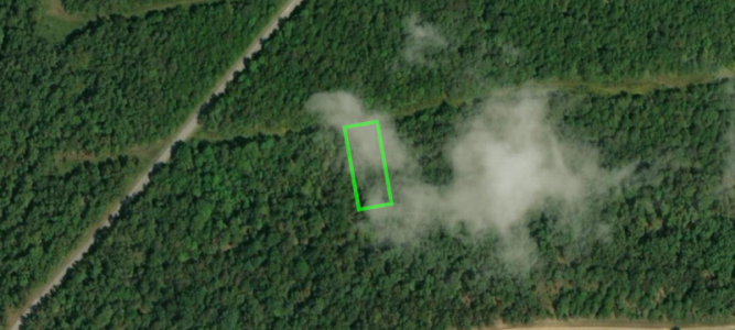
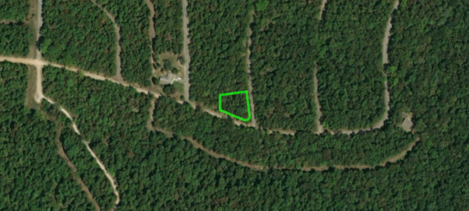
Vacant Lot 0.07 Acres in Grays Harbor County, WA. Legal: Lot 14, Block 220, First Addition to Ocosta. Parcel No. 791522001400. GPS – (46.8817438, -124.0366849). According to the Assessor the lot is in a rural area and listed as a wooded undeveloped small lot and it is between Aberdeen and Westport. The 2020 taxes of $6.78 have been paid. There are no past due taxes. According to the Owner, this is a great land lot west of the 5 Freeway in Ocosta, Grays Harbor County Washington 98520. Zoning is G5 – General Development 5 residential, Agricultural. It appears to have some wetlands. For additional zoning information, please call (360) 249-4222. The lot has low taxes and is close to the Beach and Ocean. The lot is less than a mile to Beach/South Bay, 5 miles to the Pacific Ocean/Cohassett Beach,  55 miles to Olympia/5 Freeway and 100 Miles to Downtown Seattle, Washington. There are 2 lots for sale separately and the picture below shows both lots. The other lot is parcel number 791522001000.

IMPORTANT LEGAL INFORMATION
CSAssets specializes in the liquidation of Bankruptcy Assets and Personal Assets. This is a Personal Asset. All Assets are sold “AS IS and WHERE IS” with no warranties implied or stated. The Seller  is not responsible for issues, if any, with the title, the condition of the property, accessibility or terrain. All information contained in this listing has come from reliable sources and is accurate to the best of our knowledge.  The Buyer will be entirely responsible for this property after the sale, including but not limited to: paying any fees associated with the transfer of the property, the recording of the deed and transfer of  Title and the gathering of any documentation necessary for that process. CSAssets will  provide the Buyer with a Quit Claim Deed for the property. CSAssets recommends all bidders perform their own due diligence PRIOR to bidding on this item. Please read all sections of the ad carefully, particularly for real estate sales.

LIENS
 We do not know of any liens.

LOCATION INFO
Grays Harbor County is a county in the U.S. State of Washington. The county seat is Montesano and it largest city is Aberdeen, WA. Grays Harbor County comprises the Aberdeen, WA Micropolitan Statistical Area.

NOTES
A title search has NOT been performed on this item. CSAssets does not provide title insurance. If title insurance is desired, the buyer will be responsible for obtaining it through a Title Company. A document preparation fee of $200 will apply and will be included in the total of your invoice. Serious Bidders Only. A bid submitted by a potential Buyer is an agreement to our Terms. Potential Buyers should not bid unless the fully intend to complete the sale.

Item ID: Inman41
Owner Name: Skyline Real Estate Services, LLC

845 Hunt St. Akron, Ohio

VACANT HOME SITE LOT in AKRON, OHIO!

CLICK HERE TO VIEW THE AUCTION

DESCRIPTION OF ITEM
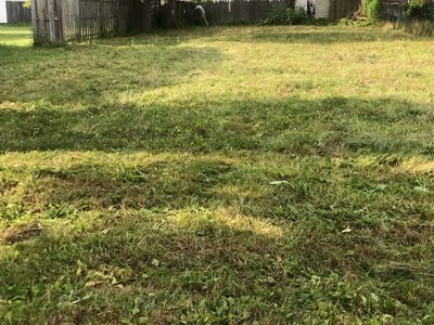
0.17 Acres (7,405 Sq. Ft.) of Vacant Land in Summit County, Akron, Ohio. Legal: Tract 9, Lot 3, Sub 14 Hunt. Parcel No. 6801288. The site address for the parcel is 845 Hunt St. Akron, OH 44306.  The 2021 taxes of $294.38 have been paid. There are no past due taxes.  According to the Assessor this is a build able lot. According to the current Owner, there previously was a house on the lot so there are utilities there. The picture below was provided by the Owner.

IMPORTANT LEGAL INFORMATION
CSAssets specializes in the liquidation of Bankruptcy Assets and Personal Assets. This is a Personal Asset. All Assets are sold “AS IS and WHERE IS” with no warranties implied or stated. The Seller  is not responsible for issues, if any, with the title, the condition of the property, accessibility or terrain. All information contained in this listing has come from reliable sources and is accurate to the best of our knowledge.  The Buyer will be entirely responsible for this property after the sale, including but not limited to: paying any fees associated with the transfer of the property, the recording of the deed and transfer of  Title and the gathering of any documentation necessary for that process. CSAssets will  provide the Buyer with a Quit Claim Deed for the property. CSAssets recommends all bidders perform their own due diligence PRIOR to bidding on this item. Please read all sections of the ad carefully, particularly for real estate sales.

LIENS
We do not know of any liens.

LOCATION INFO
Summit County is an urban county in the U.S. state of Ohio. Its county seat is Akron. The county was formed on March 3, 1840, from portions of Medina, Portage and Stark Counties. It was named “Summit County” because the highest elevation on the Ohio and the Erie Canal is located in the County.

Akron is the fifth-largest city in the U.S. State of Ohio and is the county seat of Summit County. It is located on the western edge of the Glaciated Allegheny Plateau about 40 miles south of downtown Cleveland. The city was founded in 1825 by Simon Perkins and Paul Williams, along the Little Cuyahoga River at the summit of the developing Ohio and Erie Canal. The name is derived from the Greek word signifying a summit or high point. A long history of rubber and tire manufacturing, carried on today by The Goodyear Tire & Rubber company, gave Akron the nickname “Rubber Capital of the World”

NOTES
A title search has NOT been performed on this item. CSAssets does not provide title insurance. If title insurance is desired, the buyer will be responsible for obtaining it through a Title Company. A document preparation fee of $200 will apply and will be included in the total of your invoice. Serious Bidders Only. A bid submitted by a potential Buyer is an agreement to our Terms. Potential Buyers should not bid unless the fully intend to complete the sale.

Item ID: Pasas01
Owner Name: Linda Pasas

Lot in Deer Run Addition OK

VACANT LOT in CANADIAN COUNTY, OK!

CLICK HERE TO VIEW THE AUCTION

DESCRIPTION OF ITEM
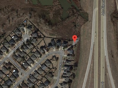
Vacant Lot 1,250 sq. ft. in Canadian  County, OK. Legal: Deer Run Addition, Section 2 Common Area “A”, Block 9. Parcel No. 060074-00900A-000000. There is no site address for the parcel though it is in a cul-de-sac at Jay Matt & Rocky Road near the Kilpatrick Turnpike. According to the Assessor, there are power and water nearby and it is the city of Yukon. The 2021 estimated taxes are approx. $0.00. There are no past due taxes.  According to the Owner the parcel is approx. 0.67 Miles to Lake Overholser, 4 Miles to Hwy 40, 10 Miles to Will Rogers World Airport and 10 Miles to Oklahoma City. The picture below was provided by the Owner.

IMPORTANT LEGAL INFORMATION
CSAssets specializes in the liquidation of Bankruptcy Assets and Personal Assets. This is a Personal Asset. All Assets are sold “AS IS and WHERE IS” with no warranties implied or stated. The Seller  is not responsible for issues, if any, with the title, the condition of the property, accessibility or terrain. All information contained in this listing has come from reliable sources and is accurate to the best of our knowledge.  The Buyer will be entirely responsible for this property after the sale, including but not limited to: paying any fees associated with the transfer of the property, the recording of the deed and transfer of  Title and the gathering of any documentation necessary for that process. CSAssets will  provide the Buyer with a Quit Claim Deed for the property. CSAssets recommends all bidders perform their own due diligence PRIOR to bidding on this item. Please read all sections of the ad carefully, particularly for real estate sales.

LIENS
We do not know of any liens.

LOCATION INFO
Situated in West-Central Oklahoma, Canadian County is bounded by Kingfisher County on the north, Oklahoma and Cleveland Counties on the east, Grady County on the South, Caddo County to the southwest and Blaine County to the northwest. The county’s northwestern corner is situated in the Gypsum Hills. Drained by the North Canadian and the Canadian rivers, which cross the county from northwest to southeast, the county consists of 905.17 square miles of land and water. The County Seat is is El Reno, Oklahoma.

NOTES
A title search has NOT been performed on this item. CSAssets does not provide title insurance. If title insurance is desired, the buyer will be responsible for obtaining it through a Title Company. A document preparation fee of $200 will apply and will be included in the total of your invoice. Serious Bidders Only. A bid submitted by a potential Buyer is an agreement to our Terms. Potential Buyers should not bid unless the fully intend to complete the sale.

Item ID: Inman39
Owner Name: Hannelore  Inman (Skyline Real Estate Services, LLC)

415 Park Circle Talladega, AL

3 BEDROOM HOUSE in TALLADEGA, ALABAMA!

CLICK HERE TO VIEW THE AUCTION

DESCRIPTION OF ITEM
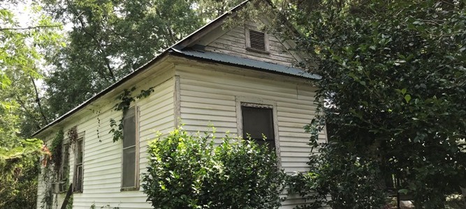
3 Bedroom and 2 bath house in Talladega, Alabama. Legal: 100′ x 150′ Highland Park Add Lots 23 & 24 of Sec 22, T18, R5, Talladega County, Alabama. Parcel No. 1305224034004000, PIN 17088. The address of the property is 415 Park Circle Talladega, AL 35160. The house has 3 bedrooms (1 bedroom  has a fireplace), a living room, kitchen with a closet/pantry and built in shelves and a laundry room. The heat is gas. The house is vacant and needs a lot of work. The 2020 taxes have not been billed out yet. There are no past due taxes. There are liens owed to the City in the amount of approx. $962.00. The pictures were take by the Owner. There are more pictures available to interested parties. Please contact me and I’ll send them to you. The Owner WILL consider all reasonable offers.

IMPORTANT LEGAL INFORMATION
CSAssets specializes in the liquidation of Bankruptcy Assets and Personal Assets. This is a Personal Asset. All Assets are sold “AS IS and WHERE IS” with no warranties implied or stated. The Seller  is not responsible for issues, if any, with the title, the condition of the property, accessibility or terrain. All information contained in this listing has come from reliable sources and is accurate to the best of our knowledge.  The Buyer will be entirely responsible for this property after the sale, including but not limited to: paying any fees associated with the transfer of the property, the recording of the deed and transfer of  Title and the gathering of any documentation necessary for that process. CSAssets will  provide the Buyer with a Quit Claim Deed for the property. CSAssets recommends all bidders perform their own due diligence PRIOR to bidding on this item. Please read all sections of the ad carefully, particularly for real estate sales.

LIENS
Past due liens owed to the City of Talladega of approx. $962.00, payable by the Buyer. We do not know of any liens.

LOCATION INFO
Talladega is the County seat of Talladega County , Alabama, United States. It was incorporated in 1835. Talladega is approximately 50 miles east of Birmingham, AL. The city is home to the Alabama Institute for the Deaf and Blind and the Talladega Municipal Airport a public general aviation airport. The Talladega Superspeedway, Talladega College and the International Motorsports Hall of Fame are located nearby.

NOTES
A title search has NOT been performed on this item. CSAssets does not provide title insurance. If title insurance is desired, the buyer will be responsible for obtaining it through a Title Company. A document preparation fee of $200 will apply and will be included in the total of your invoice. Serious Bidders Only. A bid submitted by a potential Buyer is an agreement to our Terms. Potential Buyers should not bid unless the fully intend to complete the sale.

Item ID: Crockett02
Owner Name: Abreascia Crockett

Camden, MS Lot

2 ACRES of VACANT LAND in MADISON COUNTY, MS!

CLICK HERE TO VIEW THE AUCTION

DESCRIPTION OF ITEM
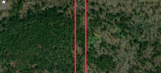
2 Acres of Vacant Land in Madison County, MI with a 15ft easement to Main Road. Legal: 2.0 AC evenly off E/S of 231/2AC off S/E SW1/4 SW1/4 PPIN 35666 Section 11, Township 10N, Range 5E. Parcel No. 105A-11-014/02.00, According to the Assessor the lot is in an unincorporated area near the Town of Farmhaven and Camden, MS. There is no site address for the parcel other than Permenter Road. The 2020 taxes of $77.01 have been paid. According to the Owner, the lot can be used for hunting or a variety of things and there is an easement off the main road. The lot is approx. 2.6 miles to HWY 16,  5 miles to 9 Miles lake, 18 miles to Ross R. Barrett Reservoir, and 40 Miles to Jackson, Mississippi.

IMPORTANT LEGAL INFORMATION
CSAssets specializes in the liquidation of Bankruptcy Assets and Personal Assets. This is a Personal Asset. All Assets are sold “AS IS and WHERE IS” with no warranties implied or stated. The Seller  is not responsible for issues, if any, with the title, the condition of the property, accessibility or terrain. All information contained in this listing has come from reliable sources and is accurate to the best of our knowledge.  The Buyer will be entirely responsible for this property after the sale, including but not limited to: paying any fees associated with the transfer of the property, the recording of the deed and transfer of  Title and the gathering of any documentation necessary for that process. CSAssets will  provide the Buyer with a Quit Claim Deed for the property. CSAssets recommends all bidders perform their own due diligence PRIOR to bidding on this item. Please read all sections of the ad carefully, particularly for real estate sales.

LIENS
 We do not know of any liens.

LOCATION INFO
Camden is an unincorporated community located on Mississippi Highway 17 in Madison County, Mississippi. Camden is approximately 12 miles northeast of Sharon and is located within the Jackson Metropolitan Statistical Area. It has a post office and a zip code of 39045. Velma Jackson High School is located in the community.

The town was named for Camden, South Carolina by Mississippi Governor William McWillie. McWillie was raised in Camden, South Carolina and was in the the South Carolina House of Representatives and the South Carolina Senate. He moved to Mississippi in 1845, where he was elected to Congress and then in 1858 he was elected the 22nd Governor of Mississippi. He is buried in Kirkwood Cemetery, outside of Camden, Mississippi.

NOTES
A title search has NOT been performed on this item. CSAssets does not provide title insurance. If title insurance is desired, the buyer will be responsible for obtaining it through a Title Company. A document preparation fee of $200 will apply and will be included in the total of your invoice. Serious Bidders Only. A bid submitted by a potential Buyer is an agreement to our Terms. Potential Buyers should not bid unless the fully intend to complete the sale.

Item ID: Inman37
Owner Name: Skyline Real Estate Services, LLC

1.5 ACRES OF VACANT LAND IN IRON RIVER TOWNSHIP, MI!

CLICK HERE TO VIEW THE AUCTION

DESCRIPTION OF ITEM
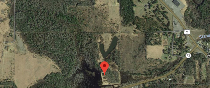
1.5 Acres of Vacant Land in Iron County, Iron River Township, MI. Legal: 695-585 607-1 148-214, Sec 28 T43N R35W, Beg at a Point on SD S BDY WH is 438′ W of SE Cor of NE 1/4 of SW 1/4; Th N 13 Deg W 360′ to Iron Pipe, Th E 182′ to Iron Pipe; Th S 13 Deg E to S BDY; Th W 182′ to POB. Parcel No. 004-028-079-00. The site was previously used as a Gravel Pit. There is no site address for the parcel, though it is near Hwy M73.  According to the Assessor, there is power and water nearby and the property is zoned Commercial. The nearest city to the parcel is Iron River, MI. The 2020 taxes of $137.98 have been paid . There are no past due taxes.  The picture below is from Google Maps. According to the Owner, the lot is 0.4 miles to HWY 2, 1.8 miles to Downtown Iron River, 1.9 Miles to Stanley Lake and 30 Miles to Eagle River.

IMPORTANT LEGAL INFORMATION
CSAssets specializes in the liquidation of Bankruptcy Assets and Personal Assets. This is a Personal Asset. All Assets are sold “AS IS and WHERE IS” with no warranties implied or stated. The Seller  is not responsible for issues, if any, with the title, the condition of the property, accessibility or terrain. All information contained in this listing has come from reliable sources and is accurate to the best of our knowledge.  The Buyer will be entirely responsible for this property after the sale, including but not limited to: paying any fees associated with the transfer of the property, the recording of the deed and transfer of  Title and the gathering of any documentation necessary for that process. CSAssets will  provide the Buyer with a Quit Claim Deed for the property. CSAssets recommends all bidders perform their own due diligence PRIOR to bidding on this item. Please read all sections of the ad carefully, particularly for real estate sales.

LIENS
We do not know of any liens.

LOCATION INFO
Iron River is a city in Iron County in Michigan. The city is situated at the southeast corner of Iron River Township. Iron County is a county in Upper Peninsula of Michigan. The county seat is in Crystal Falls, MI.

NOTES
A title search has NOT been performed on this item. CSAssets does not provide title insurance. If title insurance is desired, the buyer will be responsible for obtaining it through a Title Company. A document preparation fee of $200 will apply and will be included in the total of your invoice. Serious Bidders Only. A bid submitted by a potential Buyer is an agreement to our Terms. Potential Buyers should not bid unless the fully intend to complete the sale.

Item ID: Inman05
Owner Name: Hannelore  Inman

Lot in Pioneer Town CA

VACANT LOT NEAR YUCCA VALLEY, SAN BERNARDINO COUNTY, CA!

CLICK HERE TO VIEW THE AUCTION

DESCRIPTION OF ITEM
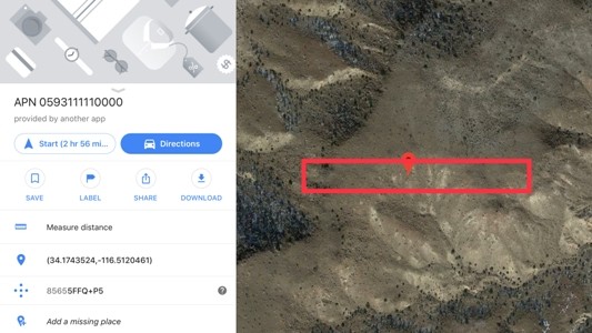
1.12 Acres 48,501 Sq. Ft. (66′ x 735′) Vacant Lot in San Bernardino County, CA. Legal: The legal description is metes and bounds. Please contact me for the full legal if you are interested in the property. Parcel No. 0593-111-11-0-000, According to the Assessor the GPS coordinates are 34.1743574,-116.512058. There is no site address for the parcel. The 2020 taxes of $167.08 have been paid. According to the Owner, the lot is approx. 1.4 miles to downtown Pioneer Town,  2.9 miles to Rim Rock, 4.1 miles Hwy 247, 5.4 Miles to downtown Yucca Valley and 12 Miles to Joshua Tree.

IMPORTANT LEGAL INFORMATION
CSAssets specializes in the liquidation of Bankruptcy Assets and Personal Assets. This is a Personal Asset. All Assets are sold “AS IS and WHERE IS” with no warranties implied or stated. The Seller  is not responsible for issues, if any, with the title, the condition of the property, accessibility or terrain. All information contained in this listing has come from reliable sources and is accurate to the best of our knowledge.  The Buyer will be entirely responsible for this property after the sale, including but not limited to: paying any fees associated with the transfer of the property, the recording of the deed and transfer of  Title and the gathering of any documentation necessary for that process. CSAssets will  provide the Buyer with a Quit Claim Deed for the property. CSAssets recommends all bidders perform their own due diligence PRIOR to bidding on this item. Please read all sections of the ad carefully, particularly for real estate sales.

LIENS
 We do not know of any liens.

LOCATION INFO
Located in southeast California, the thinly populated deserts and mountains of this vast county stretch from the roughly 480 square miles south of the San Bernardino Mountains in San Bernardino Valley to the Nevada border and the Colorado River. The county seat is San Bernardino. Father Francisco Dumetz named the County on May 20, 1810, the feast day of St. Bernardino of Siena. The Franciscans gave the name San Bernardino to the snow-capped peak in Southern California in honor of the Saint.

Yucca Valley is a town in San Bernardino County, CA. It lies 17 miles west of Twentynine Palms, 27 miles north of Palm Springs, 62 miles south of Barstow via State Route 247, 45 miles southeast of Lucerne Valley and 55 miles east of San Bernardino. It is bordered in the west by the San Bernardino Mountains and in the south by the Joshua Tree National Park, the Yucca Valley community is located in the Mojave Desert.

NOTES
A title search has NOT been performed on this item. CSAssets does not provide title insurance. If title insurance is desired, the buyer will be responsible for obtaining it through a Title Company. A document preparation fee of $200 will apply and will be included in the total of your invoice. Serious Bidders Only. A bid submitted by a potential Buyer is an agreement to our Terms. Potential Buyers should not bid unless the fully intend to complete the sale.

Item ID: Inman36
Owner Name: Skyline Real Estate Services, LLC
1219 Franklin Dr Horseshoe Bend, AR

VACANT LOT in GREEN BRIAR, HORSESHOE BEND, AR

CLICK HERE TO VIEW THE AUCTION

DESCRIPTION OF ITEM
0.39 Acre (17,174 sq. ft.) Vacant Lot in Izard County, AR. Legal: Lot 35, City: Horseshoe Bend, Addition: Green Briar. Parcel #: 800-04979-000.  The site address for the parcel is 1219 Franklin Drive Horseshoe Bend, AR 72512. According to the Assessor, the parcel is zoned residential. The parcel is in Horseshoe Bend, AR. The 2021 County taxes are estimated to be approx. $75.08. The property was purchased for taxes and according  the MRID in Horsehoe Bend there are no past due taxes. The picture below is from the Izard County website.

IMPORTANT LEGAL INFO
CSAssets specializes in the liquidation of Bankruptcy Assets and Personal Assets. This is a Personal Asset. All Assets are sold “AS IS and WHERE IS” with no warranties implied or stated. The Seller  is not responsible for issues, if any, with the title, the condition of the property, accessibility or terrain. All information contained in this listing has come from reliable sources and is accurate to the best of our knowledge.  The Buyer will be entirely responsible for this property after the sale, including but not limited to: paying any fees associated with the transfer of the property, the recording of the deed and transfer of  Title and the gathering of any documentation necessary for that process. CSAssets will  provide the Buyer with a Quit Claim Deed for the property. CSAssets recommends all bidders perform their own due diligence PRIOR to bidding on this item. Please read all sections of the ad carefully, particularly for real estate sales.

LIENS   We do not know of any other liens.

LOCATION INFO
Izard County was formed in 1825 and is named for War of 1812 General and Arkansas Territorial Governor George Izard. Horseshoe Bend, AR is a residential community nestled in the Ozark Mountains of North Central Arkansas. Property Owners have access to 2 golf courses, 3 gorgeous lakes for boating and fishing, one miniature golf court, numerous parks, a crystal clear river and much, much more. The Quiet rural area has a low crime rate is certainly one of the most affordable areas of the country to live in or retire.

NOTES
This is all we know about this asset. A title search has NOT been performed on this item. CSAssets does not provide title insurance. If title insurance is desired, the buyer will be responsible for obtaining it through a Title Company. A document preparation fee of $200 will apply and will be included in the total of your invoice. Any fees/liens owing on this item are not part of the final bidding price. Serious Bidders Only. A bid submitted by a potential Buyer is an agreement to our Terms. Potential Buyers should not bid unless the fully intend to complete the sale.

Item ID: Wakefield06

Owner Name: Kelly Wakefield

1921 Hickory Lane Horseshoe Bend, AR

VACANT LOT in WHITE OAK, HORSESHOE BEND, AR!

CLICK HERE TO VIEW THE AUCTION

DESCRIPTION OF ITEM
0.35 Acre (15,375 sq. ft.) Vacant Lot in Izard County, AR. Legal: Lot 330, City: Horseshoe Bend, Addition: White Oak. Parcel #: 800-14025-000.  The site address for the parcel is 1921 Hickory Lane Horseshoe Bend, AR 72512. According to the Assessor, the parcel is a corner lot, zoned residential. The parcel is in Horseshoe Bend, AR. The 2021 County taxes are estimated to be approx. $51.68. The property was purchased for taxes and according  the MRID in Horsehoe Bend there are no past due taxes. The picture below is from the Izard County website.

IMPORTANT LEGAL INFO
CSAssets specializes in the liquidation of Bankruptcy Assets and Personal Assets. This is a Personal Asset. All Assets are sold “AS IS and WHERE IS” with no warranties implied or stated. The Seller  is not responsible for issues, if any, with the title, the condition of the property, accessibility or terrain. All information contained in this listing has come from reliable sources and is accurate to the best of our knowledge.  The Buyer will be entirely responsible for this property after the sale, including but not limited to: paying any fees associated with the transfer of the property, the recording of the deed and transfer of  Title and the gathering of any documentation necessary for that process. CSAssets will  provide the Buyer with a Quit Claim Deed for the property. CSAssets recommends all bidders perform their own due diligence PRIOR to bidding on this item. Please read all sections of the ad carefully, particularly for real estate sales.

LIENS   We do not know of any other liens.

LOCATION INFO
Izard County was formed in 1825 and is named for War of 1812 General and Arkansas Territorial Governor George Izard. Horseshoe Bend, AR is a residential community nestled in the Ozark Mountains of North Central Arkansas. Property Owners have access to 2 golf courses, 3 gorgeous lakes for boating and fishing, one miniature golf court, numerous parks, a crystal clear river and much, much more. The Quiet rural area has a low crime rate is certainly one of the most affordable areas of the country to live in or retire.

NOTES
This is all we know about this asset. A title search has NOT been performed on this item. CSAssets does not provide title insurance. If title insurance is desired, the buyer will be responsible for obtaining it through a Title Company. A document preparation fee of $200 will apply and will be included in the total of your invoice. Any fees/liens owing on this item are not part of the final bidding price. Serious Bidders Only. A bid submitted by a potential Buyer is an agreement to our Terms. Potential Buyers should not bid unless the fully intend to complete the sale.

Item ID: Wakefield05

Owner Name: Kelly Wakefield

Lot in Falls County, Texas

VACANT LOT in FALLS COUNTY, MARLIN, TEXAS!

CLICK HERE TO VIEW THE AUCTION

DESCRIPTION OF ITEM
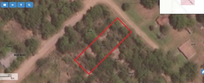
0.172 Acres (7,500 sq. ft.) Vacant Lot in Falls County, Marlin, TX. Legal: S3870 Oltorf Prentice Sub, Block 9, Lot 2A Falls County, Texas. Parcel No. 37135, Account/GEO #12272001. The site address is SM2840 aka Butler Street Marlin, TX 76661. According to the Owner, this is a great residential lot in the City of Marlin, Texas. According to the Assessor, this is a build able lot and utilities are nearby. The taxes for 2020 of $21.88 have been paid. There are no past due taxes.  The picture below was provided by the Owner.

IMPORTANT LEGAL INFORMATION
CSAssets specializes in the liquidation of Bankruptcy Assets and Personal Assets. This is a Personal Asset. All Assets are sold “AS IS and WHERE IS” with no warranties implied or stated. The Seller  is not responsible for issues, if any, with the title, the condition of the property, accessibility or terrain. All information contained in this listing has come from reliable sources and is accurate to the best of our knowledge.  The Buyer will be entirely responsible for this property after the sale, including but not limited to: paying any fees associated with the transfer of the property, the recording of the deed and transfer of  Title and the gathering of any documentation necessary for that process. CSAssets will  provide the Buyer with a Quit Claim Deed for the property. CSAssets recommends all bidders perform their own due diligence PRIOR to bidding on this item. Please read all sections of the ad carefully, particularly for real estate sales.

LIENS
We do not know of any liens.

LOCATION INFO
Falls County is a county located in the central part of the U.S. State of Texas. The County seat is Marlin. Marlin is 24 miles south of Waco and 121 miles south of Dallas. It is named for the original 10-foot-tall waterfall on the Brazos River which existed until the river changed course during a storm in 1865. The present falls can be found two miles northeast of the original falls, at the Falls on the Brazos Park, a camping site located only a few miles out of Marlin on Farm to Market road 712.

NOTES
A title search has NOT been performed on this item. CSAssets does not provide title insurance. If title insurance is desired, the buyer will be responsible for obtaining it through a Title Company. A document preparation fee of $200 will apply and will be included in the total of your invoice. Serious Bidders Only. A bid submitted by a potential Buyer is an agreement to our Terms. Potential Buyers should not bid unless the fully intend to complete the sale.

Item ID: Inman30
Owner Name: Skyline Real Estate Services, LLC
Page 4 of 66« First...345...Last »